A guide to using IBAHM
Navigating IBAHM
To search for an exit, highway, or location, type a keyword into the search bar and hit enter. Clicking a search result will bring you information about the exit, highway, or location in the sidebar and pan to it on the map. If you want to search more specifically, you can include some filters by clicking the filter button to the right of the search bar. There, you can filter by the highway, exit number, location, and exit name, as well as see highway junctions, airports, and bridges.
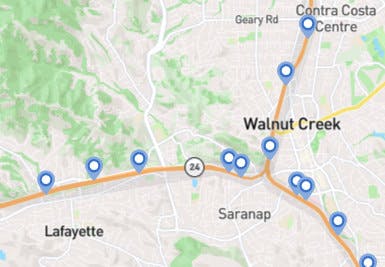
You can also use the map to look for highways and exits. Zoom in so you can see the pins on the map. Each pin represents a highway exit. Clicking on an exit will bring you information in the sidebar. Clicking on a highway on the map will bring you information about that highway in the sidebar.
Understanding IDs
Highways are assigned IDs for use within IBAHM. IDs are chosen by taking the "colloquial" name of the highway, removing the dash, and making everything lowercase (i.e. I-780's ID is i780 and SR-242's ID is sr242.)
Exits are also assigned unique IDs for the purpose of differentiating them. This is the string of characters in the last part of the URL when you visit an exit's page. They follow a specific format that details the highway on which they are on and the exit number, if applicable. An unnumbered exit will have a "u" in its ID. For example, I-680 exit 1A will have the ID "i680x1a".
Exit IDs can be input into the search bar to directly take you to the appropriate page.
Searching with IBAHM
Using the search bar, you can look for highways, their exits, or locations. Entering a simple query will bring up the most relevant results—oftentimes, exits. Searching specifically for a highway or location will bring up the highway or location on top as well as any relevant exits.
If you want a more nuanced search experience, you can use filters, which are accessible with the filter button to the left of the search icon. Here, you can refine your queries by limiting the location in which the exit appears, the highway which it is on, whether the exit leads to a bridge, or more. It is also possible to limit the amount of search results you get.
Saving and sharing exits
You can save and un-save exits to your browser by clicking the star ☆ in the bottom left corner of the sidebar. Saved exits will appear on the My saved exits page.
You can also share exits by clicking the share icon on the bottom right corner of the sidebar.
FAQ
What is the Bay Area?
The (San Francisco) Bay Area is most commonly defined as the 9 counties surrounding the San Francisco Bay. These counties are Marin, Sonoma, Napa, Solano, Contra Costa, Alameda, Santa Clara, San Mateo, and the city/county of San Francisco itself. Comprising of 7.75 million people (as of 2018), the Bay Area is home to an ethnically diverse population of people on equally diverse lands. Perhaps some of the things the Bay Area is best known for are its technology industry (being home to Silicon Valley), high cost of living, and beautiful landmarks.
Some extended definitions also include places as south as Santa Cruz and places as east as Stockton.
Why is only one side of each exit pinpointed on the map?
Only the side of the highway going westbound (if the highway is east/west) or northbound (if the highway is north/south) has pinpointed exits on the map to match the direction in which the exit numbers are increasing. For the most part, the on and off ramps for the part of the highway going in the opposite direction will be nearby, but it's not always the case. Sometimes, they will be separated due to the way nearby roads are positioned. Often times, exits will only have an entrance and exit ramp going in one direction, making for incomplete access from the highway in one direction. If this is the case, the pin will be positioned where it is possible to leave the highway.
Why is this exit signed differently than from real life?
Some exits are signed differently from real life for consistency's sake. Additionally, some exit names differ depending on the direction in which the highway heads, so one has to be chosen.
Why can't I find this city or town?
IBAHM only indexes locations that have highways that run through them (e.g. Oakland will be indexed, but Moraga won't be). If you see any errors, contact us to get them fixed.
What does unincorporated mean?
The unincorporated part of a county is the part of a county where there are no cities, towns, or any other governed subregions.

For example, the map above shows the location of Pleasanton (highlighted in red) within Alameda County. The other gray areas are incorporated areas like cities, while the white areas are unincorporated. The smaller white areas, such as Sunol, directly south of Pleasanton, are technically not incorporated, but are listed separately in IBAHM.
I have questions, comments, or have seen a bug. How do I contact you?
Contact us here.